************************************
The Hong Kong Observatory issued the Hurricane Signal No.10 in the small hours on July 24, 2012 during the passage of Severe Typhoon Vicente. This was the first No.10 Signal in Hong Kong since Typhoon York 13 years ago in September 1999.
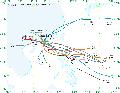
During the past 67 years (1946–2012) after the Second World War, there were 14 tropical cyclones that necessitated the issuance of the Hurricane Signal No.10 in Hong Kong. The tracks of these tropical cyclones are shown in Figure 1.
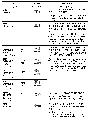
For the 13 tropical cyclones after 1946 (Note 1), four were super typhoons (maximum sustained winds of 185 km/h or above), three were severe typhoons (maximum sustained winds of 150–184 km/h) and six of them were typhoons (maximum sustained winds of 118–149 km/h) during the periods when the Signal No.8 or above were issued. The intensity and the closest approach with reference to the Hong Kong Observatory for these typhoons are shown in Table 1 (Note 2). Vicente was the farthest tropical cyclone that had necessitated the issuance of the No.10 Signal since 1946. A comparison of the maximum gust and minimum pressure recorded during the passage of Vicente and the previous tropical cyclones is shown in Table 2.
Vicente exhibited a rather unusual track over the South China Sea. It began with a westward track, stalling for about 15 hours some 350 km to the south-southeast of Hong Kong on July 22-23 before moving northwestwards towards the south China coast. It also underwent rapid intensification in 48 hours prior to its closest approach to Hong Kong, strengthening from a tropical storm to a severe typhoon. Such rapid intensification near the territory was unprecedented among the above-mentioned tropical cyclones.
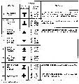
The Observatory has operated a numbered tropical cyclone warning signal system (TCWS) since 1917 to alert the public of the wind conditions in Hong Kong. The current TCWS consists of the No.1, 3, 8, 9, and 10 signals with their meaning given in Figure 2. Prior to 1973 (Note 3), the signals consisted of the No.1, 3, 5, 6, 7, 8, 9, and 10, of which the No. 5, 6, 7, and 8 all warned about gale or storm force winds, i.e. wind strength of 63-117 km/h (34-63 knots), coming from wind directions of NW, SW, NE, SE respectively (Figure 3). In order to strengthen the public understanding that all these four signals warned about the same wind strength, these signals were replaced by 8NW, 8SW, 8NE and 8SE respectively in 1973. The Observatory wishes to clarify that the No.5 signal in the past3 was the same as the No.8 NW signal today.
As regards the Signal No.9, the TCWS (Figure 2) states clearly that it is to warn the public that the gale or storm force wind is increasing or expected to increase significantly in strength over the territory. It is issued to warn the public about increasingly destructive winds and is effectively a precursor to the Hurricane Signal No.10. When the Signal No.9 is issued, all precautions should be completed and people should stay indoors and away from exposed windows and doors to avoid flying debris.
The TCWS is a proven system for many years to minimize casualties and property damages in Hong Kong due to tropical cyclones. It is important that members of the public should familiarize themselves with the signals, their meaning and the associated precautions to take.
* Note 1: Information was incomplete for the 1946 tropical cyclone
* Note 2: All information on Vicente are provisional, based on operational data
* Note 3: Earlier history of the TCWS prior to 1956 can be found at HKO webpage: www.hko.gov.hk/informtc/tcsignal_history.htm
Ends/Thursday, July 26, 2012
Issued at HKT 23:53
NNNN