**********************************************************
The Hong Kong Observatory today (June 14) reported that a squall line, which swept across Hong Kong on June 9 with peak gusts of 77 and 101 km per hour recorded at Central and Shek Kwu Chau respectively was responsible for the reports of very high winds at Ap Lei Chau and Mid-levels on Hong Kong Island on that day.
About 20 trees were blown down at Ap Lei Chau. The Hong Kong Observatory said there was no evidence to support speculation that a tornado, a waterspout or a microburst had occurred.
The observatory examined all available meteorological data and carried out a site inspection at Ap Lei Chau before making this conclusion.
A squall line is a narrow band of thunderstorms. It travels fast, wrecking havoc on its way. Apart from heavy rain and thunder, a squall line also brings a sudden change in the wind direction and an abrupt increase in wind speed.
Gusts exceeding 100 kilometres per hour are not uncommon in Hong Kong. They are very often mistakenly reported by unexperienced observers as "tornadoes".
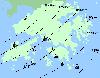
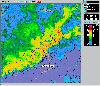
Under the influence of an active trough of low pressure, the weather on June 9 was unstable with heavy rain and squally thunderstorms. On that night, a squall line oriented from southwest to northeast developed over the Pearl River Estuary and moved southeastward across Hong Kong at a speed of about 50 km per hour between 8.30pm and 9.30pm (see Figure 1). Behind the squall line, the colder air descended from above and spread forward on hitting the ground. Figure 2 shows the radar picture shortly after the squall line crossed Ap Lei Chau.
Tornadoes and waterspouts could be detected by a Doppler weather radar. None was detected by the Doppler weather radars at Tai Mo Shan and Tate's Cairn. Furthermore, no funnel cloud characteristic of tornadoes and waterspouts was reported by local residents.
A microburst is a column of cold air descending from a thunderstorm and spreading out in all directions on hitting the ground. However, based on the pattern of fallen trees at Ap Lei Chau and eye-witness reports, winds there blew in a uniform direction throughout the event, which does not support the existence of a microburst.
Other examples of severe squall lines previously reported in Hong Kong are: May 9, 2001 and May 9, 2005.
Some information on the characteristics of squall lines and the events on May 9, 2005 are available from the links below:
http://www.weather.gov.hk/wxinfo/news/2005/pre0509e.htm
http://www.weather.gov.hk/education/edu01met/wxphe/ele_squalle.htm
Ends/Wednesday, June 14, 2006
Issued at HKT 19:56
NNNN